A key consideration for regeneration and place-making is to deliver supporting infrastructure for changing communities.
This may include new schools, medical facilities, roads and transport hubs, cycle paths, walkways and green infrastructure.
Regeneration links to other areas including Planning and the Infrastructure Delivery Plan, to ensure the right infrastructure schemes are brought forward.
New infrastructure in our regeneration projects include:
- Harold Hill Town Centre – a new family welcome centre and medical facility
- Bridge Close, Romford – a new primary school and medical centre plus environmental improvements to revitalise the River Rom
Here are some of the recent infrastructure projects we have been working on.
These projects were part of Havering’s plans to compliment the arrival of Crossrail coming through the borough with public realm improvement measures made possible by funding from Transport for London.
Crossrail (now officially known as the “Elizabeth Line”) is the major new cross-London rail link project which has been developed to serve London and the southeast of England. It will support and maintain the status of London as a ‘World City’ by providing a world class transport system.
This regeneration programme took place at three Network Rail stations on the Elizabeth Line across the borough:
The Beam Parkway scheme aims to transform a 2.2 km stretch of highway along the A1306 from dual carriageway to predominately single lane carriageway.
The redundant carriageway will be replaced with trees and natural planting that will create a sense of parkland and coordinated frontage for the new developments.
It is a complementary infrastructure scheme for the regeneration of Rainham and Beam Park.
The scheme will create safe cycle routes and walkways connecting the new developments within Rainham and Beam Park Housing zone to local facilities and transport hubs, including Rainham Village.
Unfortunately, the scheme is on hold as Transport for London (TfL) funding has been withdrawn due to their financial difficulties as a result of the pandemic.
The Council continues to be committed to the scheme and is pursuing other funding options
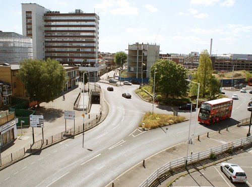
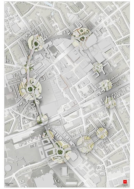
The Romford Ring Road Scheme aims to strengthen walking and cycling connections between Romford Town Centre and the surrounding area.
This will promote the town centre economy and make people feel safer.
It will provide up to 10 surface level pedestrian crossings with trees and planting; underpasses will be filled in and planted.
These are initial proposals and the detailed design will be confirmed after public consultation.
The images below shows the Ring Road as it is now and demonstrates the barrier that it creates for pedestrians and cyclists wanting to cross the road to the Town Centre, and what it could look like.

The Land of the Fanns Landscape Partnership Scheme aimed to restore, discover and celebrate one of the last remaining London landscapes as it once was. “Fanns” derives from the Saxon word for fen.
The scheme delivered landscape and local history projects as part of a Landscape Conservation Action Plan which relates to the north bank of the River Thames in East London and South Essex.
The projects are now complete and the Land of the Fanns Legacy will be led by Thames Chase Trust Thames Chase Community Forest in partnership with Local Councils, the Forestry Commission, Thames 21 and Thames Estuary Partnership.
- 10 May 2017 - Cabinet report